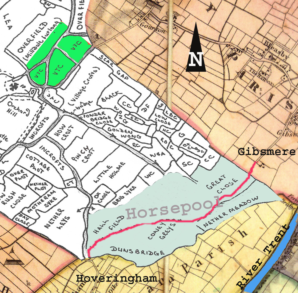
Somewhere in the parish of Thurgarton is the lost village of Horsepool. The Victoria County History of Nottinghamshire claimed that it lay 1 mile to the north of Thurgarton village but other evidence points firmly to the south of the parish close to the River Trent (1) . The earliest mention of Horsepool in Domesday includes it within the vill of Thurgarton but provides no clue to its size or location.
The main written source for Horsepool can be found in the Register or Cartulary of Thurgarton Priory where several charters of land grants in Horsepool are recorded from the 12th and 13th centuries (2) . These charters include many of the field names of Horsepool some of which survived into 18th century parish surveys and maps. One such field, Dunsbriggefurlong, lay in the south-western corner of the parish next to Hoveringham. The fields of Horsepool appear to have occupied the southern part of modern Thurgarton parish and lay between Hoveringham and Gibsmere.
Fig 1 Fields of Horsepool in south of Thurgarton parish (white) – Thurgarton village – green, Horsepool fields -blue, old road -red
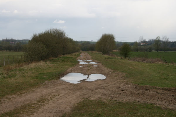
One of the Horsepool charters refers to a toft (cottage) and the wall of a grange which were located close to ‘the king’s highway’ (4). The king’s way referred to is the bridle road which was one of the main routes from Nottingham to Newark. The road appears on all the early parish maps and ran from Hoveringham Mill ( here it was called Milngate) across the southernmost fields of Thurgarton parish and onto Gibsmere and the Trent crossing at Hazelford. Horsepool evidently lay alongside this road most of which is now merely a footpath but parts of the original wide trackway survive.
Fig 2 Old road towards Gibsmere
In 1328 a survey of the lands of Thurgarton Priory mentions John Criol’s hall in Horsepool; Hall field was a large field which bordered Hoveringham and the name suggests this may have been the site of his hall. The Criols (or Kiriolls) appear to have been the main landowners in Horsepool; initially they were probably subtenants of the Dayncourt barons who were Lords of the Manor of Thurgarton but by the 14th century much of Horsepool belonged to Thurgarton Priory to which the Criols made several gifts of land (5).
The Horsepool charters refer to cottages, gardens, a barn and closes but only seven householders were identified in the the 1328 survey of Thurgarton Priory (compared with over 60 householders in Thurgarton), suggesting that Horsepool was a small community. One can picture a hamlet close to the Criol’s hall or grange lying alongside the old road – in character and size somewhat similar to its near neighbour, Gibsmere, in Bleasby parish.
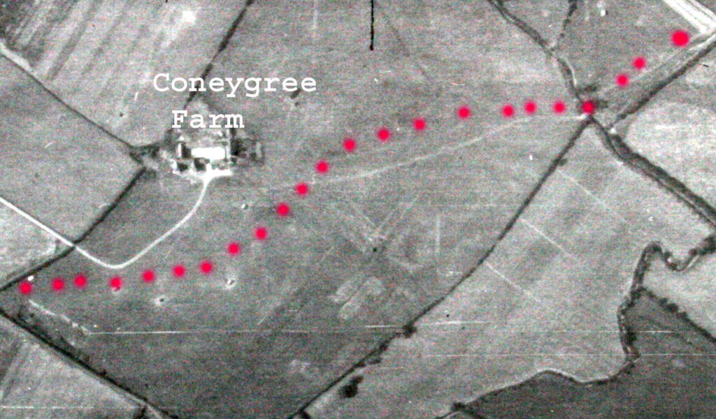
Sadly any vestige of Horsepool’s cottages, walls or hall has been obliterated by extensive gravel extracton in the 1950-60s; every field in the parish south of the railway line was excavated. Some aerial photos however were taken before the gravel extraction; in figure 3 below, a possible trackway surrounded by humps and cropmarks can be seen with the eye of faith in the field adjacent to Coneygree farm.
Fig 3 Aerial photo 1948 showing Coneygree farm and with possible trackway (red dots), cropmarks and humps in field (6)
In 1949 these features came to the attention of local archaeologists. They reported a sunken trackway next to several humps some nearly 30 ft across; excavation of one of these humps revealed a scatter of skerry stone and mediaeval pottery. Although no definite remains of houses etc were uncovered they concluded with suprising confidence that ‘ these humps are the remains of the long lost village of Horspol’ (7). Their OS grid reference for this site places it just south-east of Coneygree Farm. In 1961 close to the above location an old well and further mediaeval pottery were uncovered. All of this site was subject to gravel extraction – if this was Horsepool it now lies 40ft down.
Deserted Mediaeval Villages
Deserted Mediaeval Villages (DMVs) hold an especial interest for local historians who popularised this area of study 60 years ago. The list of such deserted sites has increased to many thousands and they raise the obvious question as to why such villages disappeared from the landscape; their study however has revealed not only why villages died but also how they were born, grew, shrank and shifted in the landscape (8).
There is no single cause for the death of these villages. The Black Death would undoubtedly have depopulated most communities and rendered some nonviable but many survived this catastrophe; some succumbed to land enclosure, others disappeared in the planning of new country houses and parkland, some were swallowed up in industrial expansion, new reservoirs, natural disasters etc- the list of causes is a long one (9).
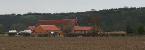
Horsepool certainly survived the Black Death. The last reference to Horsepool Grange is in 1539 on the sale of Thurgarton Priory land to William Cooper. Later surveys of Thurgarton merely refer to the fields of Horsepool and no mention is made of tofts, barns or hall. The grounds of Horsepool are recorded in the 1730 survey and map of Trinity College estate in Thurgarton.; they lie just across the border in Gibsmere close to Glebe Farm, which has recently been renamed Horsepool Grange.
Fig 4 Horsepool Grange, Gibsmere
Horsepool’s demise seems to date to the 16th or 17th century but the estate records give no indication of exactly when and why it disappeared. It was owned by Trinity College Cambridge who leased their lands to several generations of the local squires – the Cooper family. Estate improvement with enclosure is a possibility but so is repeated flooding from the Trent – we can only speculate.
The mediaeval charters and surveys name several of the Horsepool folk – Margery the widow of William Frauncey, Thomas the Pinder, Richard Petrich, Richard Willan, Wiiliam Asger and several generations of Criols. Some would have adopted the name Horsepool as their family name – a not uncommon surname in this area.
References
1 Victoria County History of Nottinghamshire, vol.1, p.273
2 T.Foulds, The Thurgarton Cartulary, (Stamford, 1994) pp.31-45
3 Nottinghamshire Archives Office , maps M12612, M12613 and T. Foulds, map 2
The main road through Thurgarton (the A612) is nowadays a busy highway and pedestrians attempting to cross can grow old waiting for a gap in the traffic. The photographs and postcards below take us back to late Victorian and Edwardian Thurgarton.
A time when —
— children could play in the middle of the road
— and a farm lad could take his time driving a cow down the highway.
A time when horse drawn carts travelled at walking pace although a pony and trap could travel at a fair lick especially coming down the hill —
— but going up Thurgarton Hill, which was much steeper in those days, one had to pace oneself.
It was advisable to take refreshment before starting the climb at The Coach and Horses.
— or stop halfway up at the Red Lion
— and if one had over refreshed and suffered a breakdown then simply roll back down to the smithy at the crossroads.
The earliest parish maps of Thurgarton were drawn up about 1730 to settle a land ownership dispute between Trinity College, Cambridge and the Cooper family.
The Coopers owned most of the north of the parish and lived in a Tudor mansion next to the parish church. In 1726 a rough sketch of the Cooper lands showed fields, woods and lanes (blue in map 1); their land was chiefly low hilly country of heavy clay soil extending down to the escarpment of the Trent Valley. They also leased much of the Trinity College land and acted as Lords of the Manor.
Trinity College Cambridge had been granted the village and southern half of the parish by Henry VIII. The 1731 map of Trinity College land (white in map 1) included not only village buildings, gardens, fields and lanes but also the names of each householder and the land that they rented from the college
Combining these two maps provides us with the only detailed pre-enclosure map of Thurgarton parish.
Map 1 Thurgarton parish c 1730
Land usage in Thurgarton
The field names and layout provide some insight into land usage not only in 1730 but also for the preceding centuries for many of these 18th century field names can be traced back to the early Norman period in the land grants of the register or cartulary of Thurgarton Priory indicating that the basic pattern of land usage in the parish had not changed for at least 500 years.
Map 2 Basic land use in Thurgarton parish
1. Wooded parkland in the north (green in map2) – Overwood, Bankwood, Parkwood, Southwood, Youngwood.
A park at Thurgarton was part of the endowment grant by Ralph Dayncourt to Thurgarton Priorywhich he founded in c 1130. This was probably a deer park and sections of a ditch and bank , remnants of a possible deer fence and a deer leap, can still be seen on the northern boundary of the parish.
In 1536 the Prior of Thurgarton sold timber from ‘his park at Thurgarton’ to the Duke of Rutland to rebuild Belvoir Castle. The contract describes the extent of the park which appears to have covered most of the north of parish and was evidently heavily wooded given the size of the timber contract – 1200 large oaks over 10 years.
Mediaeval wooded parkland was a valuable asset and besides hunting and timber it also was a source of fuel for domestic hearths and for small scale industrial furnaces; charcoal and tile making are both recorded in Thurgarton. In winter fodder for livestock included woodland leaves and pigs were allowed to forage for acorns and roots. The villagers collected woodland plants and berries to supplement their diet or for medicinal use.
‘The Park’ persists in modern Thurgarton but has shrunk to an area of new houses and adjacent fields to the west of the church.
2. Assart ( yellow in map 2) –Thwaite, Intake and Riddings
These names are typical of woodland which has been cleared for ploughing
(assarting) and which would have been incorporated into the open field system described below. These fields are named in mid-13th century land grants to the Priory which would be consistent with the increasing village population of this period and consquent need for more arable land. The mediaeval method of ploughing with ox teams along narrow strips of land gave rise to the typical ridge and furrow patterns which have survived in many lowland parishes of Britain and are visible on field walking or in aerial photographs.
3. Arable open fields ( brown in map 2) – Great field, Over field, Spital field.
These arable strips of plough land surround the village and lie on the well draining escarpment land. The land strips (selions) are clearly seen on the Trinity map (map 3) and aerial photos clearly show ridge and furrow patterns for Great Field and the assarted fields above.
Map 3 Trinity estate with arable strips coloured in two tone green
The pattern of arable fields is consistent with a three or four field rotational system of land use in the parish. Again several of these small strips of ploughland are mentioned in land grants to the Priory in the 13th century and earlier.
4. Pasture and meadow ( blue in map 2)- Nether Leys, Nether Meadow
The wet valley floor provided ideal pasture land and hay meadows and numerous small closes for livestock. Records indicate rearing of pigs, cattle and sheep and the name Coneygree indicates a rabbit warren (much prized by the early Norman lords and by modern Frenchmen ).
Village plots and householders
The village was owned by Trinity College and so appears on the college map.
Map4 Trinity College estate in Thurgarton, village highlighted
In this map houses and barns were denoted by letters ‘H’and ‘B’ ; in map 6 below the houses are in red, barns and outbuildings in brown, the school in orange and alms houses pink.
Map 6 Thurgarton village c 1730
There were 27 named householders each with their house and outbuildings set in typically elongated plots of land – the croft. Each householder is listed in map 7 below with a colour code for their corresponding house and croft.
Map7 Village plots with householder
The map also identifies the fields worked by each villager; they are shown in map 8 using the same colour code as in Map 7 above.
Map 8 Land worked by each householder – colour code as in map 7
Each householder worked several widely seperated fields and strips of ploughland. This is more clearly seen if we simply look at one individual – John Brettle ( misspelt Bretton on the original map).
Map 9 Village plot and fields rented by John Brettle
Thurgarton was a typical East Midlands parish with a single centrally positioned village surrounded by three or four large open fields worked on a yearly rotation system which would have been closely supervised by the villagers in their local Manorial Court. The parish stretched from wooded upland in the north to the well drained fertile escarpment on which stood the village and on to the the river valley with its pastures and meadows – an ideal balance of woodland, arable and pasture making the parish almost self-suffient for most of its needs.
This ancient pattern of land usage by the village community was to change dramatically before the end of the 18th century when enclosure came to the parish and will be the subject of another article.
Groceries were delivered fortnightly to the village; a man came round on a Tuesday to take your order and it was delivered ten days later on a Friday. If you had forgotten anything it was just too bad, you had to wait another fortnight or hope the village shop had it. The Baker’s van was horse drawn as was the Greengrocer’s dray pulled by a horse called Bob. Meat was delivered to all the houses twice a week and a fishmonger came once a week on a motorbike and sidecar.
We had to cycle to Lowdham or Southwell for a haircut; it cost 3d by hand clippers and 4d when electric clippers came in. We would also cycle to Lowdham to collect a recharged accumulator for the wireless. We used to get dog meat from Hoveringham; it was horse meat painted with a green dye to stop you using it to eke out the meat ration.
Special days
Sunday was always treated as Sunday with no work on the farm apart from the essential work like milking cows and feeding the animals. We all wore our Sunday best clothes and went to church on Sunday morning, Sunday school in the afternoon and evening service later. In the summertime families went for a long walk after church on Sunday evenings. In winter Sunday meant a fire in the front room, the piano was played, stories told and games played.
On Armistice Day every year the whole country came to a standstill for the two minute silence to remember the dead of the First World War. Everything stopped and everyone observed the silence, the majority gathering around the war memorials in every town and village. Before the war school holidays included Oak Apple Day on May 29th to celebrate King Charles hiding in an oak tree, Trafalgar Day on October 21st –the Battle of Trafalgar, Pancake Day and Empire Day.
The Silver Jubilee of George V in 1935 was celebrated in style with the villages dressing up with flags and bunting and holding sports and street parties; we even named one of our horses ‘ Jubilee’. Granddad Robert bought all the children in the village a Jubilee Mug; it was the last generous offer of his life as he died later that year. Two years later in 1937 the celebrations were all repeated at the coronation of George VI.
Coronation day 1937 Thurgarton
Games and hobbies
In pre-war days we played the usual football with jackets for goal posts, cricket with a rubber ball and stumps chalked on a wall and rounders. We also played tracking, fox and hounds, bowling a hoop (an old bike wheel without spokes), marbles, whip and top, cap guns, wheel barrows made from old pram wheels, conkers, roller skating, scootering, and cycling as far a field as Newark, Nottingham and on one day Doncaster. The games seemed to go in seasons. In spring it was skipping for the girls, marbles and whip and top for boys. In winter there was sliding on frozen ponds, sledging on Booker’s field, roller skating and tracking. In summer it was cricket and rounders and cycling and in autumn of course it was conkers and fox and hounds –a great time was had by all.
Collecting cigarette cards was a good hobby and every subject you could think of was represented : fish, flowers, trains, footballers, cricketers, animals, film stars, flags, ships and aeroplanes, to name a few. We used to go to a building site in Thurgarton on Sundays when the builders were off and collect almost a full set of cards from all the empty cigarette packets – a few swaps completed the set.
Train spotting , taking steam locomotive names and numbers, was a popular pastime. Newark was the place to go, to the LNER (London and North Eastern Railway) to see such famous engines as; The Flying Scotsman, The Mallard, Silver Link, Silver Fox, Sir Nigel Gresley and Silver Jubilee. Not many ‘Names’ passed through Thurgarton on the Derby to Lincoln line but quite a few could be seen at Nottingham Midland Station( London, Midland and Scottish Railway), especially the ‘City Class’ locomotives. Some Sundays ‘Uncle’ Harry , a train driver on the LNER, would take us to Colwick marshalling yards and give us rides on the steam loco around the yards. The engines were always coaled up and serviced on Sundays with grease gun, oil can and oily rag.
School holidays
School holidays were not all work on the farm. Fishing in the Beck we would catch eels, Bully Heads, Sticklebacks, Red Breasts, Silver Breasts, and minnows. Collecting tadpoles or newts from the various ponds around the village was also popular. We would go to see Mr Foster , the cobbler, to listen to his stories from the Great War or go to the blacksmiths shop to see Jack Milner and pump the bellows for the furnace to heat the horseshoes. One day one of our horses, Blossom, went to be shod and while Jack Milner had gone across the road to his house the horse walked home on her own and was found standing on the bridge with her head over the farm gate waiting for someone to open it.
Sometimes we visited Ernie Paling the joiner and wheelwright and watched him make coffins or repair wagon wheels. The railway station was another port of call to watch the steam pick-up which came every morning at eleven o’clock to collect or drop off trucks. The porter and signalmen always needed assistance to pull the levers for the points and signals. Mrs Statham at the village shop was another popular place where we could spend our pocket money – we could buy half penny worth of aniseed balls, liquorice, a packet of sherbet or chocolate drops.
Mrs Statham outside the village shop and post office 1937
Village entertainments
There were concerts, whist drives and dances at the ‘The Hut’ –the village hall which was an old WW1 army hut. The Harvest Supper was held every year as was the annual Parochial Tea at Christmas when all the villagers got together for a meal. Food was provided by all the village folk followed by a dance and entertainment. The village comedian was George Allwood who based his act on George Robey; then there was Aunt Alice who recited hilarious poems. The dance music was provided by local bands led by Jack Penson or Vic Cotton or Frank Whitehead – what a lot of talent there was around the area.
In 1935 Mr Ford who lived on the Park made a 16mm film all about Thurgarton and its inhabitants. Most of us were on that film which was always shown at the village dos in the Hut. He also invited all the village to his house on 5th November and put on a brilliant firework display and a large bonfire.
The Hut being painted by Fred Farrands
Entertainment outside the village
Other highlights of the year were Lowdham Flower Show in August, when the Borstal Boys from Lowdham Grange gave an excellent gymnastic display, Lowdham Feast in September, Newark May Fair and Nottingham Goose fair in October. The fair amusements ( supplied by Hibble and Mellors of Nottingham) included Gallopers, Dodgems, Noah’s Ark, Cake Walk and The Chair O’Planes. All were powered by electricity generated by those magnificent immaculate steam engines with their highly polished brasses. The noise , the smell of the steam and smoke, the fair organs pumping out their music, the brandy snaps, the coloured balls, swing boats, coconut shies – all these gave real character to the fairs of those days.
There were three cinemas in Newark ( Savoy, Palace and Kinema), the Ideal in Southwell and over forty in Nottingham. We regularly visited The Empire Theatre to see Variety Shows and Music hall including all the popular stars of the day such as George Formby, Gracie Fields, Rob Wilton, Stainless Stephen and Jack Warner. We saw such bands as Joe Loss, Geraldo, Billy Cotton, Troise and his Mandoliers, Big Bill Campbell and his Rocky Mountain Rhythm, Sid Millwall and his Nitwits . We went every year to the pantomime at Nottingham Theatre Royal which always had top stars like Arthur Askey and Max Wall.
A night out at the cinema would cost about 4 shillings – 1s for the train fare, and the cinema was from 9d to 1s 6d for a 3-4 hour programme of the main feature , a second B film , newsreels and cartoons as well as forthcoming attractions and trailers. Some also had a cinema organ which played for about 20 minutes and everyone joined in the sing song. Afterwards it was fish and chips, mushy peas, bread and butter and tea – all for 1s 6d at Newbolds Café. It wasn’t unusual in the war to see Italian POWs wandering around Newark on a Saturday night, walking or cycling.
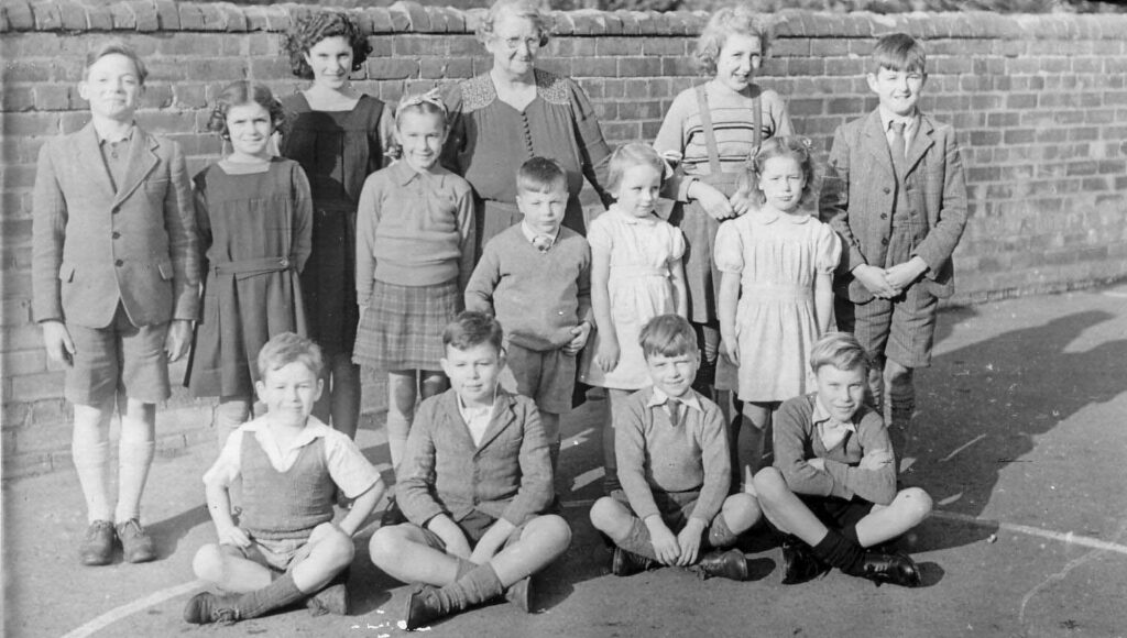
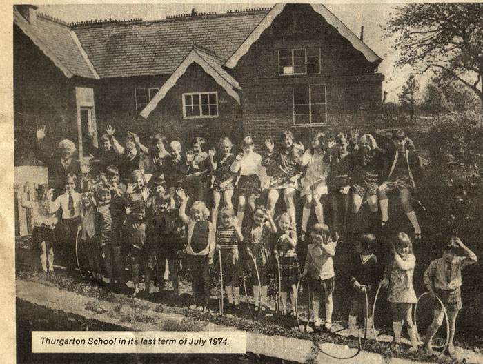
Village school
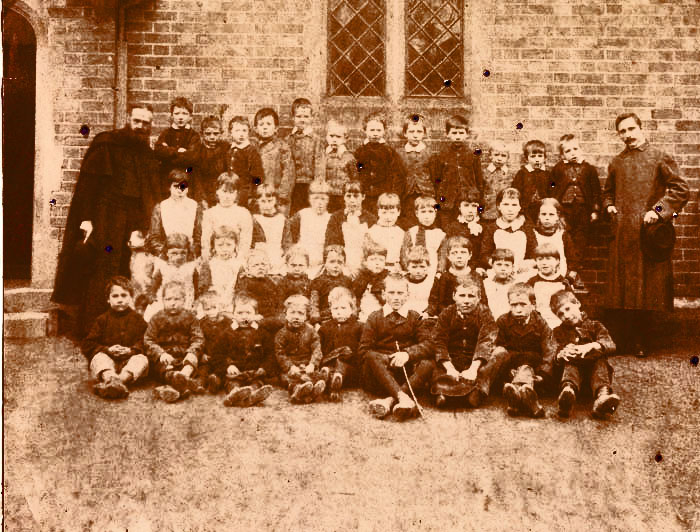
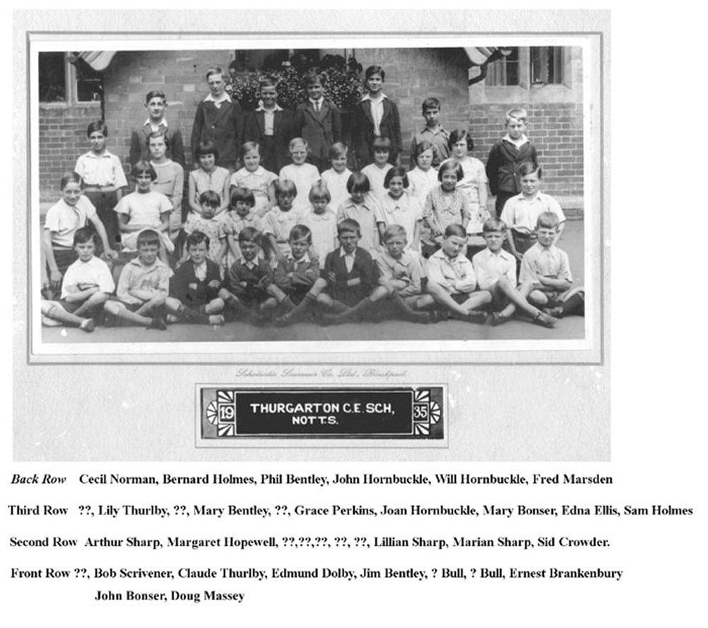
Thurgarton school 1935 – Jim Bentley is in the centre of the front row
I spent 5 years at Thurgarton school which was a small school with two classrooms. Mrs Beech was the headmistress and taught the 10 to 14 year olds ( school leaving age), and Miss Ethel Fletcher ( Aunt Ethel, our Mum’s sister ) taught the 5 to 9 year olds so just two classes for all ages. As we lived next door to the school we went home every day for dinner. There was no gym or sports field so PT was done in the playground as was country dancing and the maypole. I remember Mrs Beech stepped back and fell over the Maypole stand and broke her arm so we had a temporary teacher from Nottingham who introduced us to Sir Julian Cahn – the great cricketer.
At Christmas we always had a party and a school play. Mr Nicholson , the school attendance officer, often visited the school and woe betide anyone who had been absent without good reason. The nit nurse was also a regular visitor complete with nit comb to check everyone’s hair. The worst week of the year was the arrival of the school dentist in his caravan and his foot powered treadle drill to do the fillings.
The Minster school
I took the 11plus at Barnby Road School in Newark but failed, so dad paid for me to go to Southwell Minster School for boys – the fee was £4-11s per term. Discipline was strict. The cane or walking stick or ruler was the order of the day depending on the master’s taste, as was the degree of punishment to be meted out – it was a powerful deterrent. I remember two boys being expelled for smoking in the toilets ; they were brought in front of the whole school and expelled on the spot. We heard later that one of them had been killed in action in the war.
Mondays, Wednesdays and Fridays we had to stay late for rugby, cricket or cross country running depending on the season and we still had homework to do after returning home at seven. I wasn’t a boarder and cycled eight miles there and back each day in all weathers. We had to go to school on Saturday mornings until 1 o’clock and one of the worst punishments was being kept in detention on Saturday afternoon. There were about 100 boys at the school in five forms and this doubled when the evacuees arrived from Worthing School began at 9.30 am with a walk to the Minster each morning for prayers and hymns. One of the boys, Roy Long, played the Minster organ; he was a brilliant pianist and organist from the age of twelve.
At lunchtime we were allowed to go into Southwell and all headed for Mosedales the Bakers for a penny currant bun and a penny bar of nestles chocolate. On Fridays as a treat we went to Jones the Bakers for a cream bun. One day I was walking back to school with cream bun in hand behind my back when a dog pinched it out of my hand. School dinners were 9d and consisted of lots of baked potatoes, corned beef, prunes and rice, prunes and custard, or just prunes. During the war more school dinners ended up in the static water tank than were eaten and rice puddings were flicked onto the ceilings.
Every spring we had a race from Southwell to Bleasby , Morton and back. The school masters rode on bikes and once John Carding and I were walking along this road when we were suppose to be running and the French Master came along on his bike and caught us; he took a pin out of his lapel and kept jabbing our backsides to keep us running – we ran off across a field and then went back to walking – he kept shouting at us and we were disqualified.
School days were not the happiest days of my life as we were always being told off – they spoilt a wonderful childhood.
Jim Bentley, Margaret Allwood ( Reeves) and Mary Bentley
When Charles I raised his standard in Nottingham on 22nd August 1642, men of property and influence were forced to choose between supporting Parliament or their King. In Nottinghamshire most of the landowning gentry were staunch royalists including Sir Roger Cooper of Thurgarton who lived at Thurgarton Priory, a Tudor house built by his great grandfather on the remains of a partially demolished Augustinian Priory.
1632 tapestry map showing Tudor house at Thurgarton (1)
Sir Roger was a magistrate and in 1639 when High Sheriff of Nottinghamshire was responsible for the collection of the increasingly unpopular taxes levied by the court – Ship Money and Coat and Conduct Tax. Increasing numbers of tax defaulters were recorded in the county records of the 1630s including the entire townsfolk of Newark who withheld payment.
In the 17th century county affairs were controlled by the gentry who owed their appointments to the crown. The gentry in turn appointed village officers who ran parish business. The Protestation Returns of 1641 for Thurgarton lists 66 male householders and identifies Michael Poyser as Constable , Matthew Brettle and Henry Forrest as Churchwardens, William Holmes and Thomas Turvey as Overseers of the Poor and Zachariah Trigg as Minister. The fortune of the village in the ensuing conflict would depend on such men of standing in the community but most of all on Sir Roger and his choices.
Civil War in Nottinghamshire
A few months after the outbreak of civil war the royalists garrisoned and fortified Newark which gave them control of vital road and river routes; the town proved to be one of the main centres of royalist strength throughout the war. Less than 20 miles away the parliamentarians, under Colonel Hutchinson, took control of Nottingham and its castle.
Sir Roger Cooper fortified his house and stables at Thurgarton; and similar garrisons were established at Wiverton, Newstead, Shelford, Belvoir Castle and Staunton so providing a screen of royalist outposts around Newark.
Royalist garrisons in red
Caught between the Royalists in Newark and the Parliamentarians in Nottingham, life in the intervening villages such as Thurgarton was dominated by the competing needs of both armies for manpower, horses, transport, food, fodder, and arms. Village constables continued to raise taxes imposed by whichever side controlled their district and with the fluctuating fortunes of the war some villages found themselves supplying alternating sides or worse were plundered if they had been too supportive of the opposition. In garrison villages and towns the troops were billeted on the locals so further stretching local supplies(2). Occasionally foraging parties could be diverted from their duty as were Colonel Harper’s men who were persuaded not to seize horses from Thurgarton by the provision of 2s 6d of ale.
The royalists at Newark dominated most of the county in the early years of the war and launched a number of attacks on Nottingham; in September 1643 they came close to overrunning the town driving the parliamentarians troops into their last redoubt – the castle (3). In 1644 the tide of war turned and Parliament with their Scottish allies took control of the North. Newark became a target for repeated parliamentary attacks but held out to the final days of the war.
Trouble at Thurgarton
One abortive attempt to take Newark late in 1644 started with an attack on the small royalist force at Thurgarton. This account is taken from the memoirs of Lucy Hutchinson wife of Colonel Hutchinson the parliamentary Governor of Nottingham (4). Parliament ordered “ all the horse of Nottingham and Derbyshire to join with three regiments of Yorkshire and quarter about Newark to straighten the enemy there; and accordingly they rendezvoused at Mansfield and from thence to Thurgarton where Sir Roger Cooper had fortified his house and lined the hedges with musketeers who, as the troops passed by, shot and killed one Captain Heywood, whereupon Colonel Thornhagh sent to the Governor and desired to borrow some foot to take the house. The Governor accordingly lent him three companies of foot who took the house and Sir Roger Cooper and his brother and forty men in it who were sent prisoners to Nottingham ; where , although Sir Roger Cooper was in great dread of being put into the Governor’s hands, yet he received such a civil treatment from him that he seemed to be much moved and melted atit.’
1726 Buck’s print of Thurgarton Priory and church
After taking Thurgarton the parliamentary foot and cavalry marched to Southwell where dissension broke out between the foot soldiers who had done most of the fighting at Thurgarton and the cavalry who had confiscated all the plunder taken there. The Nottinghamshire horse harassed the surrounding countryside but were poorly disciplined and failed to set a night guard. A royalist foray from Newark ‘ beat up their quarters’ and captured two troops of parliamentary horse and so this particular threat to Newark melted away.
Thurgarton was plundered and the surrounding countryside was ‘ miserably distressed’ . Thoroton ‘s history of Nottinghamshire mentions the damage done at Thurgarton ‘the woods being also extremely wasted’ (5). The winter of 1644/5 must have been an especially hard time for the villagers.
Local lore claims that a mass grave of men and weapons was unearthed in a sheepfold near Magadales Farm and an old stunted elm tree near the priory was said to have been cut in half by Cromwell’s cannon. What is certain is that musket balls can be found in the gardens next to Castle Hill.
Musket balls from Castle Hill
In May 1646 Charles Stuart surrendered to the Scots army at Kelham and a sort of peace was restored to the country.
Sir Roger Cooper recovers his estate
Late in 1646 Sir Roger Cooper was evidently a free man and spent much of the following year in London attempting to recover his estate which had been confiscated by Parliament. Many hundreds of fellow royalists faced this same dilemma and were required to pay enormous fines to regain their property. Sir Roger was in correspondence with Dr Huntingdon Plumtree a physician and one of the parliamentary committee who had controlled Nottingham during the war. Huntingdon, an avowed atheist with an acerbic wit, was one of the faction within Nottingham who had plagued Governor Hutchinson and provoked severe censure in Lucy Hutchinson’s memoirs (6).
The tone of the letters between Cooper and Plumtree was friendly and Cooper was evidently being financed by the good doctor. Sir Roger apologised for the prolonged delays in his business due to long queues at Guildhall where the Parliamentary Compounders worked slowly through long lists of royalists.He requests more money for his expenses for he was not allowed to collect the tithes and rents from his estate(7). Eventually Sir Roger was fined £2,256 by Parliament and to meet this enormous penalty he sold his land and property in Fiskerton, Morton and Bleasby (including Ashwell Hall) to Dr Plumtree for almost the same amount of money as his delinquency fine – £2,250 (8). However that was not the end of Sir Roger’s financial troubles for Parliament demanded another £1200 before he was allowed to repossess his property; this was reduced on appeal in 1651 to £270 by which time he had mortgaged his estate for £8000. He died in debt as did his son John
Second Civil War
In 1648 Charles 1 escaped and allied himself with the Scots whose relations with the English Parliament had deteriorated into open warfare. In 1648 a Scots army marched down into Lancashire but in mid August the parliament’s army overwhelmed the Scots at Preston. Amongst several abortive royalist uprisings in 1648 a force of 400 horse and 200 foot soldiers marched from Pontefract to Lincoln and on towards the vale of Belvoir. On 5th July 1648 a parliamentarian force led by Col. Rossiter defeated the royalists after 2-3 hours of bloody hand-to-hand combat at Willoughby. Casualties were severe and amongst the royalist prisoners were John and Cecil Cooper, sons of Sir Roger Cooper of Thurgarton. How long they were held captive is not known but both were again at liberty in the early 1650s.
The Commonwealth and Protectorate
Charles Stuart the ‘man of blood’ was found guilty of treason and executed at Whitehall on January 30th 1649. The following four years saw a confused struggle for power between the Army and Parliament until Cromwell imposed his rule as Lord Protector in 1653 until his death 5 years later.
Execution of Charles I
In 1655 a group of royalists formed a secret committee – the Sealed Knot. In collusion with the future Charles II in exile in the Low Countries, they planned a series of royalist uprising; plans for Chester, Lincolnshire, and Yorkshire all came to nothing and in Cornwall Penruddock’s rebellion was rapidly crushed. In Nottinghamshire a planned uprising involved Sir Roger Cooper’s sons, John and Cecil who were ringleaders in the plot. They mustered a small force of men and a cartload of weapons at Thurgarton; according to local versions of the story they met at the remote farm of Thurgarton Quarters which lay on the route northwards to Oxton and Sherwood Forest.
Thurgarton Quarters farm lies in the north of the parish on the road to Sherwood Forest
Here is Wood’s description of these events in March 1655:- ‘Late on Thursday night March 8th little files of horsemen threaded their way along the dark lanes of Sherwood Forest to the appointed rendezvous on the green before the New Inn close to Rufford Abbey and the cart of arms was brought from Thurgarton. By 11pm about 300 royalist conspirators had assembled. The two Cooper brothers, Gilby, Barker and the other gentlemen went into the inn to discuss their plans while their followers waited on the green outside. At midnight or a little later Captain John Cooper came out, and telling the assembly that they were betrayed, he bade every man to shift for himself. On Cooper’s announcement some of the men flung their arms into the neighbouring pond and the meeting rapidly melted away into the darkness’ (9).
The intention had been for the Rufford assembly to join forces with a similar body of Yorkshire royalists and march north to seize York. Both Cooper brothers were arrested, Cecil Cooper was permitted to leave England and brother John eventually escaped and fled overseas probably to join the circle of royalist exiles in the Low Countries.
The Restoration
Sir Roger Cooper died in 1657. His younger son, John, was still in exile and in 1658 John Cooper’s wife, Jane, wrote to Richard Cromwell the new Protector begging permission for her husband to return ‘ that he may live quietly’. We have no record of a reply to this letter but John and Cecil Cooper were probably amongst the host of returning royalist exiles that accompanied Charles II in 1660.
Charles II
Charles II was in no position to financially restore the lost fortunes of his loyal followers many of whom had to content themselves with the royal gift of honorary court appointments – John Cooper was appointed ‘Carver to his Majesty’. Indeed Charles II’s government was short of funds and resorted to a raft of new taxes and John Cooper as his father before him was resposible for their collection in Nottinghamshire. He was described as ‘ a very industrious person who died in 1672 in his majesties debt having been Receiver General of the Royal Aid and Additional Supply and Collector of Hearth taxes in this county’. His older brother, Cecil Cooper, also returned from exile and served as a magistrate from 1660 to 1674 and as deputy lieutenant of the county; he died in 1675 and was buried in Thurgarton church.
Graveslab of Cecil Cooper
Revenge?
With the exception of the regicides most leading parliamentarians escaped severe retribution. Governor Hutchinson’s house at Owthorpe was plundered in December 1660 on the orders of Captain Cecil Cooper possibly in revenge for the despoiling of his father’s estate in Thurgarton six years previously.
Lucy Hutchinson complained bitterly of Captain Cooper’s raid on her home but three years later he redeemed himself by an act of kindness to her imprisoned husband. Hutchinson was initially allowed his liberty but in 1663 he was arrested and imprisoned at Newark prior to his transfer to the Tower. In poor health his transfer was delayed by order of Cecil Cooper and he was allowed a last visit to his family at Owthorpe (10). He died of fever in Sandown Castle in 1664.
Conclusion
The great Nottinghamshire historian,Thoroton, writing only a few years after the Civil War describes Sir Roger Cooper as:‘ a worthy honest gentleman whose fidelity and constancy to the royal interest weakened his fortunes so that Cecil Cooper esquire his son will have too hard a task to make his house and demesnes entirely his own’ (11). The same could have been said of many worthy and honest gentlemen on both sides of the divide. As for the villagers of Thurgarton we have no record of how many shared Sir Roger’s loyalty to the king but what is certain is that they along with the ordinary men and women of England suffered years of hardship.
They were poorly served by both King and Parliament.
References
1 Tapestry Map of Nottinghamshire commissioned by Mary Eyre in 1632 and held at Nottingham City Museums.
2 M.Bennett, The Civil Wars in Britain and Ireland (Blackwell 1997), pp.176-9
3 C:\Documents and Settings\Owner\Desktop\civil war\The Nottinghamshire Heritage Gateway Events The English Civil War Overview.mht
4 L. Hutchinson, Memoirs of the Life of Colonel Hutchinson (J.M.Dent 1969), pp.190-1.
5 R.Thoroton, Antiquities of Nottinghamshire1677, edited 1790 by J.Throsby, (reprint 1971 E.P.Publishers) p.59
6 http:/www.oxforddnb.com/view/article/71045 – biography of Dr Huntingdon Plumtree
7 Nottinhamshire County Archives, DD.2B 2/17-51, letters between Cooper and Plumtree.
8 House of Commons Journal V 5 : March 9th 1648 and House of Lords Journal V 10 15th April 1648
9 A.C.Wood, Nottinghamshire in the Civil War, (S.R. Publishers, Wakefield 1971), pp.166-9
10 Hutchinson pp.302-3
11 Thoroton p.59
Other Sources
M. Ashley, The English Civil War ( Stroud 2001 reprint)
M.Bennett, The Civil Wars Experienced (Routledge 2000)
I. Brown, The Civil War in Nottinghamshire (Notts County Council 2000 reprint)
Copwell, 17th Century Nottinghamshire County Records
A. Fraser, Our Chief of Men (Phoenix 1973)
M.Honeybone, The Vale of Belvoir (Barracuda Books 1987) pp.39-62
The document shown in Figure 1 is kept in the Archives of Trinity College Cambridge. It dates from 1576 and lists all the tenants in Thurgarton who rented land from the College (1).
Figure 1 List of tenants in Thurgarton in 1576
All of the village and the southern half of the parish had been granted to the College by Henry VIII after the dissolution of the Augustinian Priory of St Peter at Thurgarton. At the same time the Cooper family had purchased the priory buildings and land in the northern half of the parish; they subsequently leased the college land in the parish for many generations.
Over 640 acres were held by 41 tenants; the largest farmed 80 acres but most only 1 to 3 acres. 5 of the tenants were women including Elinor Cooper, the widow of the late Lord of the Manor, Thomas Cooper; she continued as leaseholder of the college lands in Thurgarton after her husband’s death.
Attached to the document is a second page shown in figure 2 on which is a list of names of 15 tenants alongside their individual marks; each has a separate and distinctive mark.
Figure 2 Fifeteen tenants names alongside their individual marks
All 15 who made their mark are found in the full list of tenants in the first document and include both large and small landholders but no women; the remaining 26 tenants appear to have consented to a communal mark ” and also done by me with the consent of all the rest”
A transcription of the names with their corresponding marks is shown below.
There are no duplicate marks and each is distinctive. Two or three may reflect the initial letter of the tenant’s name eg Wiggin and Smalley but the others do not and vary from simple lines and circles to much more elaborate flourishes.
The use of marks to prove one’s identity or proclaim ownership dates from early human history – from marking one’s territory with symbols to branding livestock or slaves. In the mediaeval period even the educated and literate who were able to write their names still employed symbols as proof of their identity – carved rings or matrices which they imprinted in wax.
The marks we see in these documents from16th century Thurgarton are very different from the usual ‘X’ mark seen in wills and other signed mediaeval documents. Similar symbols are seen in 13th century estate books from Northamptonshire but were used to denote the size of each tenant’s holdings(2). These symbols from Thurgarton are more reminiscent of those employed by stonemasons, merchants or carpenters and it may be that they were similarly employed to confirm ownership of livestock, agricultural or trade implements, furniture and any moveable item essential to one’s living. They appear to be parish brand marks and were used by all ranks of the parish society from William Wiggin who held a mere 2-3 acres to John Mayfield who rented 9 acres and Thomas Mawer and John Grundy who rented 40 to 80 acres.
Consultation with both county and national archives have failed to produce similar parish wide use of such symbols; it is possible that such parish marks were in common use but documents such as this one rarely survived. Anyone who knows of similar examples – please contact me.
Note on the Grundy family
John Grundy was mentioned in Thomas Cooper’s will “I give my servant John Grundy the tenement he occupies for his natural life and to his son Michael Grundy and heirs and I give MargeryGrundy my Nurse five marks (money) for remembrance as a servant ” In 1614 his son Michael Grundy was refused the style of gentleman by Norroy King of Arms but by 1628 the family was described as :- ‘The Grundies of Bleasby with a coat of arms argent on a cross engrailed between four lions passant gardant gules five marlets or and a crest of four demi-lion rampant gardant sable besanty’
Looking back to the parish marks in the 1576 document that of John Grundy stands out as the most impressive and suggests an ambitious man – his family rose from servant to gentleman in three generations
References
1 Trinity College Cambridge Archives Box 37 Thurgarton Item 16
2 M.T.Clanchy, From Memory to Written Record England 1066-1307 (Blackwell 1993 ) Plate XV Estate book of Richard Hotot
Brick is the main building material of the mid-Trent valley and on sunny days gives a pleasing glow to the village scene.
Thurgarton in the sunshine
In contrast with its neighbouring villages however Thurgarton also has considerable quantities of stone in its walls, barns, gardens and older buildings.
Coach and Horses, Thurgarton built mainly of skerry stone
Most of this stone is local skerry stone which has a grey cut surface that varies from flakey lamina when cut across the grain and whirling patterns when en face.
The geological map below reveals an abundance of skerry stone in the hills of the northern half of the parish – the bands of skerry stone are shewn in grey on the map. The Mercian Mudstone (previously called Keuper Marl ) gives rise to heavy clay soil interspersed with beds of green-grey skerry stone and occasional deposits of pink marl.
Thurgarton parish geology from B G S map of Nottingham sheet 126
The mediaeval field map of Thurgarton includes ‘Stone Pit Close’ whose location corresponds to one of the skerry stone outcrops in the geological map and may well have been the major quarry site for local skerry stone in the parish including that used in the construction of the Augustinian Priory of St Peter built in the 12-13th century.
Modified from centre of BGS map above – Stone Pit Close is circled in red and the Priory is marked by the red triangle, 250m apart
In addition to this grey skerry stone a more compact beige coloured stone is found in the village. This is white Mansfield stone, a sandy dolomitic limestone used in the construction of Southwell Minster in the 12-13th century. Many of the blocks found in Thurgarton still exhibit the diagonal chisel marks of the mediaeval stonemason; others are carved pieces which allow an accurate identification of their source as the 12-13th century Augustinian Priory of St. Peters at Thurgarton. The stonemasons who built Thurgarton Priory therefore had a ready supply of rough stone on their doorstep and an established source of better quality stone from the Mansfield quarries.
Mansfield and skerry stone
Village Stone Survey
A village stone survey in 2008 under the direction of church archaeologist Dr Jenny Alexander revealed numerous pieces of old priory stone in village buildings, walls and gardens.
The distribution of priory stone (red dots) in Thurgarton
One purpose of the survey was to use the old priory stones scattered through the village like jigsaw pieces to reconstruct the buildings of the Augustinian Priory – a work in progress to which we shall return in a later article.
Some examples of priory stone in village gardens and walls
The reuse of Priory stone
The survey also revealed how stone from the priory had been recycled through the centuries – good stone was never wasted. Some priory stone may have found its way into the village in the 16th century. At the dissolution in 1538 the Priory was sold to the Cooper family who demolished most of the priory buildings and recycled the stone to build their Tudor mansion but some stone was evidently ‘adopted’ by the locals – the scullery end of one of the older cottages has large blocks of carved and dressed Mansfield stone one of which bears the date 1593.
Even more priory stone would have been recycled in the 18th century when the Coopers demolished their Tudor house and in the 1770s built a new brick mansion and walled garden so releasing large amounts of good quality stone. Enclosure of the parish land and agricultural improvements saw a huge investment in land drainage, new farmhouses and large threshing barns. Several Georgian farmhouses were built in the parish including Hill Farmhouse which was faced with fine ashlar blocks of priory stone some of which still retain the mediaeval mason’s marks.
Hill Farm house
Outside the village eight large threshing barns were built of skerry stone in this period; some of this stone may have been from the priory but new local quarrying was probably necessary for such large scale building.
Four of the eight threshing barns in Thurgarton parish
Within the village old priory stone appears in several barns such as one in The Hollows built in 1775 by John Hart of Old Farm.
Towards the end of the 18th century brick was becoming more popular and old priory stone may have been used up – in 1790 John Hart (junior) used brick not stone in constructing the handsome barn next to his farmhouse.
Thurgarton first appears in the written records in Domesday as Turgarstune (1). The village name in the official documents of the following centuries has several forms:- Turgareston, Turgardton, Thurkarton, Thorgeirton, Torgerton, Thurgarthton and Thorgarton. Such variation in spelling was common in mediaeval records and it was not until the 17-18th century that the modern spelling of Thurgarton became the standard form. What is the origin of the name?
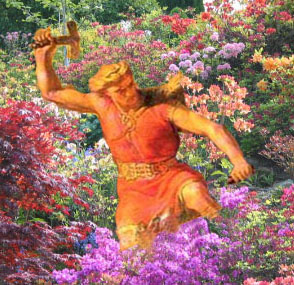
Thor’s garden? The Nottinghamshire historian Rastall chose the Thorgarthton version and maintained that the name derived from the Norse god Thor, garth a garden and ton a homestead or estate (2). This conjures up the unlikely image of the mighty hammer wielding god enjoying his Trentside garden.
Thor enjoying some light horticulture
A brave novice monk? Another famous Nottingham historian W E Doubleday ascribed the name to Turgar, an Anglo-Saxon novice monk who according to The Crowland Chronicle survived the Danish raid on Crowland Abbey in 870AD (3).
When the mass was finished, just as the abbot and his assistants had partaken of the holy communion, the Danes burst into the church. The abbot was slain upon the holy altar by the hand of the Danish king Oskytal, and the other priests and monks were beheaded by the executioner.The old men and children in the choir were seized and tortured to disclose where the treasures of the abbey were concealed, and were also put to death with the prior and sub-prior.
Ruins of Crowland Abbey
The boy apparently escaped from the Danes and returned to serve as a monk in the restored abbey where he died at the great age of 115. Doubleday has him founding a religious cell in Nottinghamshire around which grew the community of Turgar’s tun
A Danish warrior/settler? Norse god or a brave novice monk, both are rejected by modern academics who firmly trace the village’s name to the Scandinavian personal name Thorgeirr and the AngloSaxon ton meaning settlement or homestead.. This combination of Scandinavian and AngloSaxon elements, labelled a ‘Grimston Hybrid’ by place name experts, is common in parts of the East Midlands especially in the Trent Valley and implies the Danish takeover of an existing Anglian estate (4).
The Viking incursions into 9-10th century England led to a major change in the political and cultural life of the land. Historians still debate whether this was a small warrior class of Danes wresting lordship of Anglian lands or a major Scandinavian migration and settlement. Whichever is true the result was a major division of England into the north-eastern counties (the Danelaw) and the surviving Saxon kingdoms of the south and west. A new Anglo-Scandinavian society emerged in the Danelaw which became part of a thriving North Sea culture.
Saxon control of the eastern half of the old kingdom of Mercia was lost when Alfred and Guthrum agreed in c886 on a settled frontier based on Watling Street. Fortified towns or burghs were established on both sides of the border; in the East Midlands the Danes established the territory of the Five Boroughs – Nottingham, Derby, Lincoln, Stamford and Leicester.
It was some time in the 10th century, probably during a period of Saxon dominance, that the four county structure of the region was established based on Derby, Leicester, Lincoln and Nottingham (Stamford lost out). Counties were divided into smaller administrative units. Called hundreds in southern counties, they were given the Scandinavian title of wapentakes in the northern Danelaw counties. Amongst the eight wapentakes of Nottinghamshire was that of Thurgarton (later combined with Lythe) which stretched from Ossington in the north to Sneinton on the outskirts of Nottingham town to the south and contained over 60 parishes (many of the modern parish boundaries were also established in this period)
Wapentakes of Nottinghamshire
So Thugar’s tun gave its name to both parish and wapentake – obviously a place of some importance in 10th century Nottinghamshire.
Other Thurgartons Only one other village shares this name – Thurgarton in Norfolk which lies 5 miles south of Sheringham. This part of East Anglia was firmly brought under Danish control in the same period as the East Midlands. We will never know if this was the same Thorrgeir.
A Thurgarton Wood Farm (now Thurgarton Wood House) is found in the parish of Potter Hanworth in the Kesteven district of Lincolnshire. Walter first Baron Dayncourt was granted land by William 1 in Lincolnshire, Nottinghamshire and Derbyshire. His main holdings were concentrated a few miles south of Lincoln City, around his caput (headquarters) at Blankney. Amongst his other lands was the vill of Thurgarton, Nottinghamshire where in the 1130s his son Ralph founded an Augustinian Priory. The Thurgarton Cartulary records that in the 13th century, Philip of Martin (Ralph’s great grandson) made several grants of land in Potter Hanworth to the priory including ‘all his wood called Northhagge’ (5).
Potter Hanworth Wood and Thurgarton Wood House – Google Earth
18th century enclosure maps of Potter Hanworth show that the modern Potter Hanworth Wood was then much larger consisting of Norman Hagg Wood in the south, Great Wood in the middle and Quern or Queen Dike Wood in the north. Enclosed within the latter was Thurgarton Wood Farm. It seems reasonable to link this farm’s name with the 13th century grant to Thurgarton Priory.
References
1 J.E.B. Gover, A. Mawer, and F.M. Stenton (eds.), Place-names of Nottinghamshire, English Place-Name Society, vol. 17 (1940), p.178
2 F.C. Laird: Beauties of England and Wales – Nottinghamshire (1813) p.274
3 W.E. Doubleday, Scrapbook V111. p.47. Nottingham Local Studies Library
4 M.Gelling, Signposts to the Past, Phillimore, (1992), pp.228-235.
5 T. Foulds, The Thurgarton Cartulary, Stamford (1994), pp. 419-20.
Beck Street in Thurgarton has been described as one of the gems of Nottinghamshire and from the early days of photography in the late 19th century many images have recorded the scene . Here are a few.
Victorian photo of children on one of the bridges over the beck
There were three farms in the village. Horses, cows and sheep all contributed to a steady supply of fertilizer for the gardens – the locals name for Beck Street was ‘ Cow Muck Lane’.
Cow Muck Lane
Mr Allwood , Priory Farm, leading cart horsesdown Beck St. 1940s
The beck has been a playground for generations of children.
The Bentley sisters fishing 1930s
But it can change from pleasant stream to a torrent.
The beck in spate 1970s
Beck street today.
Beck Street today
Artist’s sketch of Beck Street with old stepping stones.
Artist’s sketch of Beck Street with old stepping stones